A network of towns and the distances between them in kilometres is shown. --- 2 WORK AREA LINES (style=lined) --- --- 4 WORK AREA LINES (style=lined) ---
Networks, STD2 N2 2023 HSC 19
A network of running tracks connects the points `A, B, C, D, E, F, G, H`, as shown. The number on each edge represents the time, in minutes, that a typical runner should take to run along each track. --- 4 WORK AREA LINES (style=lined) --- --- 4 WORK AREA LINES (style=lined) ---
Networks, STD2 N2 2019 HSC 30
The network diagram shows the tracks connecting 8 picnic sites in a nature park. The vertices `A` to `H` represents the picnic sites. The weights on the edges represent the distance along the tracks between the picnic sites, in kilometres.
- Each picnic site needs to provide drinking water. The main water source is at site `A`.
Draw a minimum spanning tree and calculate the minimum length of water pipes required to supply water to all the sites if the water pipes can only be laid along the tracks. (2 marks)
--- 6 WORK AREA LINES (style=lined) ---
- One day, the track between `C` and `H` is closed. State the vertices that identify the shortest path from `C` to `E` that avoids the closed track. (1 mark)
--- 1 WORK AREA LINES (style=lined) ---
Networks, STD2 N2 2011 FUR2 1
Aden, Bredon, Carrie, Dunlop, Enwin and Farnham are six towns.
The network shows the road connections and distances between these towns in kilometres.
- In kilometers, what is the shortest distance between Farnham and Carrie? (1 mark)
--- 1 WORK AREA LINES (style=lined) ---
- How many different ways are there to travel from Farnham to Carrie without passing through any town more than once? (1 mark)
--- 1 WORK AREA LINES (style=lined) ---
Networks, STD2 N2 EQ-Bank 27
Consider the network pictured below.
Find the length of the shortest path from A to E. (2 marks)
--- 4 WORK AREA LINES (style=lined) ---
Networks, STD2 N2 EQ-Bank 19
An estate has large open parklands that contain seven large trees.
The trees are denoted as vertices A to G on the network diagram below.
Walking paths link the trees as shown.
The numbers on the edges represent the lengths of the paths in metres.
Jamie is standing at A and Michelle is standing at D.
Write down the shortest route that Jamie can take and the distance travelled to meet Michelle at D. (2 marks)
--- 3 WORK AREA LINES (style=lined) ---
Networks, STD2 N2 EQ-Bank 24
Describe the shortest path between A and J in the network above and its weight. (2 marks)
--- 4 WORK AREA LINES (style=lined) ---
Networks, STD2 N2 EQ-Bank 23
A network of roads is pictured below, with the distances of each road represented, in kilometres, on each edge.
A driver wants to travel from A to H in the shortest distance possible.
Describe the possible paths she can take, and the total distance she must travel. (2 marks)
--- 5 WORK AREA LINES (style=lined) ---
Networks, STD2 N2 2011 FUR2 1
Aden, Bredon, Carrie, Dunlop, Enwin and Farnham are six towns.
The network shows the road connections and distances between these towns in kilometres.
- In kilometres, what is the shortest distance between Farnham and Carrie? (1 mark)
--- 1 WORK AREA LINES (style=lined) ---
- How many different ways are there to travel from Farnham to Carrie without passing through any town more than once? (1 mark)
--- 1 WORK AREA LINES (style=lined) ---
An engineer plans to inspect all of the roads in this network.
He will start at Dunlop and inspect each road only once.
- At which town will the inspection finish? (1 mark)
--- 2 WORK AREA LINES (style=lined) ---
Networks, STD2 N2 2010 FUR2 2
The diagram below shows a network of tracks (represented by edges) between checkpoints (represented by vertices) in a short-distance running course. The numbers on the edges indicate the time, in minutes, a team would take to run along each track.
A challenge requires teams to run from checkpoint `X` to checkpoint `Y` using these tracks.
What would be the shortest possible time for a team to run from checkpoint `X` to checkpoint `Y`? Mark the shortest route on the diagram below. (2 marks)
--- 4 WORK AREA LINES (style=lined) ---
Networks, STD2 N2 2017 FUR2 1
Bus routes connect six towns.
The towns are Northend (`N`), Opera (`O`), Palmer (`P`), Quigley (`Q`), Rosebush (`R`) and Seatown (`S`).
The graph below gives the cost, in dollars, of bus travel along these routes.
Bai lives in Northend (`N`) and he will travel by bus to take a holiday in Seatown (`S`).
- Bai considers travelling by bus along the route Northend (`N`) – Opera (`O`) – Seatown (`S`).
How much would Bai have to pay? (1 mark)
--- 1 WORK AREA LINES (style=lined) ---
- If Bai takes the cheapest route from Northend (`N`) to Seatown (`S`), which other town(s) will he pass through? (1 mark)
--- 1 WORK AREA LINES (style=lined) ---
Networks, STD2 N2 2013 FUR2 1
The vertices in the network diagram below show the entrance to a wildlife park and six picnic areas in the park: `P1`, `P2`, `P3`, `P4`, `P5` and `P6`.
The numbers on the edges represent the lengths, in metres, of the roads joining these locations.
- In this graph, what is the degree of the vertex at the entrance to the wildlife park? (1 mark)
--- 1 WORK AREA LINES (style=lined) ---
- What is the shortest distance, in metres, from the entrance to picnic area `P3`? (1 mark)
--- 1 WORK AREA LINES (style=lined) ---
Networks, STD2 N2 2014 FUR1 3 MC
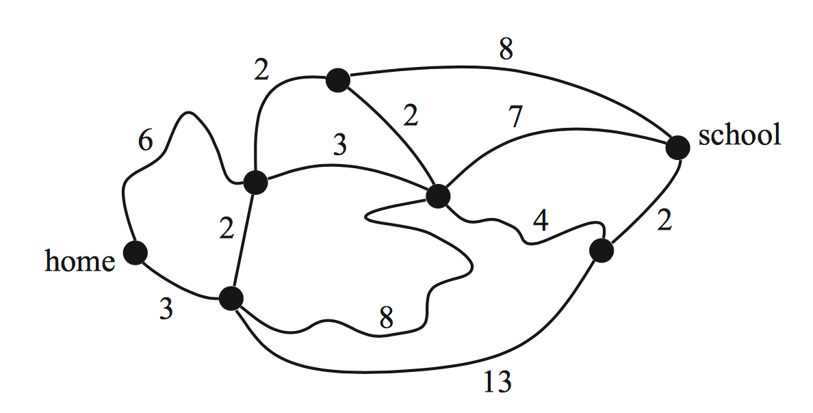
The diagram below shows the network of roads that Stephanie can use to travel between home and school.

The numbers on the roads show the time, in minutes, that it takes her to ride a bicycle along each road.
Using this network of roads, the shortest time that it will take Stephanie to ride her bicycle from home to school is
A. `12\ text(minutes)`
B. `13\ text(minutes)`
C. `14\ text(minutes)`
D. `15\ text(minutes)`
Networks, STD2 N2 2007 FUR1 4 MC
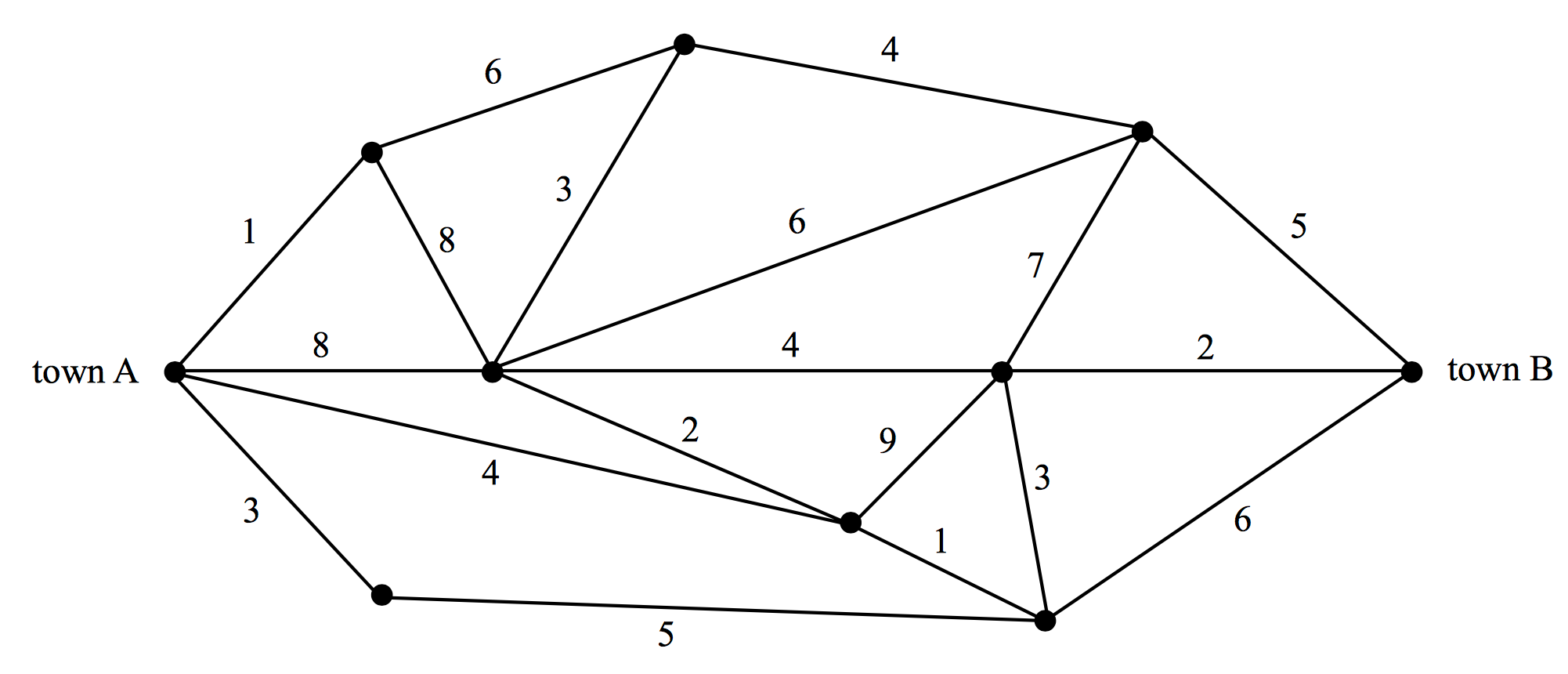
The following network shows the distances, in kilometres, along a series of roads that connect town `A` to town `B.`

The shortest distance, in kilometres, to travel from town `A` to town `B` is
A. `9`
B. `10`
C. `11`
D. `12`


